Greetings, my readers, the few hardy souls who haunt these pages. I've been working with some new technology for the coming tour--a Samsung Galaxy 8.9" tablet. The goal is to save weight and bulk and be able to update the blog, check email, etc. from towns and other wifi areas along the way. I'll have more on the Galaxy soon, but the main issue here is that I'm finding it extremely difficult and cumbersome to draft in a word program and copy/paste to blogger. Blogger eliminates basic formatting, so multiple paragraphs become one big, hard-to-read block. Ugh. There really seems to be no simple way around this. One key consideration is that I be able to draft wherever I may be then quickly post once we get to a hotspot. Not happening on blogger, it seems.
Soooo...for the duration of the tour, and for the coming weeks, too, I'll be developing a Crazyguyonabike.com journal:
Divide by Three
Honestly, although I've been enjoying some aspects of learning how to use the tablet, if I'd known in advance what a hassle it would be for the job I want it to do, I would have probably skipped the purchase and just lugged one of the netbooks we have. Still, I think we'll save about a pound, so that's something. I need to look at importing a few posts from this blog to give the readers over there some background.
So let's say that An American Explorer is going on holiday over to Crazyguyonabike.com. See you there!
Thursday, July 5, 2012

Wednesday, June 20, 2012
Gear talk: Sleepy time

This is the first in a series of posts that will deal with our gear selections, new and stuff we've had for a while. Although it's possible to take on an adventure like this for comparatively little money, our version involves some investment, not the least of which is arranging for a house sitter for four months and renting and driving a vehicle into back-of-beyond Canada--well, Jasper, anyway. For others considering cycle touring, these posts will serve as a resource for making selections. I have my biases, which will become clear soon enough, but my goal is always to give good information.
As the sub-title of the post suggests, this is about getting sleep, laying one's pedal-thrashed carcass down for a few hours of much needed regeneration before getting up and doing it all over again. In this area, I will cut no corners, spare no expense, and deal with extra weight as necessary. Having a comfortable platform for hanging out and sleeping is one of the most important considerations for me and Jodi. If I don't sleep well, the whole experience starts to unravel--as do I.
My equipment has gone the standard evolutionary route, I suppose. When I was quite young (early/mid-teens), I could sleep on those spongy, flesh-colored "insulite" foam pads, but by my late teens, those days were over. Next began a decades-long relationship with the Thermarest corporation. I've had 1" pads (too thin), and for years and years used the 1.5" model, usually 3/4 length so I had to put something under my heels to make the pads workable. Finally, we said, and I quote: "Screw it!" And went with the deluxe 2" "Camp Rest" model, complete with chair kit cover, for a lot of life in camp is not in the horizontal plane. We sit to cook, eat, gawk at the sunset, so a comfortable chair is important, too. With this setup, you are the King of Kings on his throne:
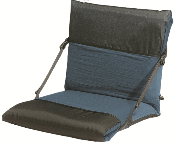
The Camp Rest and this chair kit were on my bike for my 2007 cross country ride. In general, I was quite happy with it, but still, like a junkie, I craved more, thicker, softer, yummy sleepier! So we tried the Big Agnes line of air mattresses, a high-tech rework of the classic design:

These are light and comfortable, if a bit noisy to sleep on. The down side? The chairs are not the most sit-friendly, although these were okay. The big problem with Big Agnes is production quality. We've had three of these fail along the seems, resulting in very annoying leaks that left us with limp pads in the morning and the occasional refill in the middle of the night. I cannot recommend this brand. Sorry, Big Aggie, we love your tent (more on that in a later post), but we'll pass on the pad.
So my quest for the perfect pad was unfulfilled, the Grail illusive, the Sorcerer's Stone hidden. Thanks to the glories of the Internet, I found--to date--the best sleeping system for my needs: Exped. Below is a photo of the Exped Synmat 7 long:

This line of pads, designed by a Swiss wizard, has some very nice features. The pads are almost 3" thick, have a soft-to-the-touch top fabric, and, get this, have their own built in pump system:

The pump is constructed of a one-way valve inside and to the left of the visible plastic valve. Just pop the inlet valve, place hands as indicated, and start pushing. My large pad 78 x 26" inflates in two minutes or less. No light-headed staggering about after a day on the open road, and no damp air injected into the pad. Here's a view showing how to inflate:
The pad also has an excellent chair sleeve that stays on the unit. Here's a pic of the Exped next to my Camp Rest:

Here are the two pads rolled, side by side:

Sunday, June 17, 2012
Thinking about The Big One...

With the conclusion of Vision Quest 2012, my thoughts and actions related to human powered travel have turned to The Big One, the monster tour that lurks in our future, creeps into our thoughts, our dreams, our wallets. Our goal, which I may have mentioned before, is to load Jodi, me, the hound Django, two trikes, a trailer, and touring gear into a one-way rental van and maroon ourselves in the wilds of Canada. Then over the next four months we will struggle south, crossing, recrossing and crisscrossing the Continental Divide many times down to Silver City, New Mexico. Then we will turn west and cross the Sonoran and Mojave deserts to get home. Most of the route will be paved, but we've worked in a couple of significant dirt road passages through the Colorado Rockies, including one pass over 12,000 ft., which will be the high point of the tour for sure. In 2007 when I did my solo cross country tour, the original plan had been to do it as a couple, but Jodi's career was heating up, and she had work to do. Now we're taking this big leap together. Based on my research so far and what I already know about the route, this may turn out to be the finest of all possible north American tours. Don't get me wrong. There are many beautiful parts of the country, but week upon week of corn and soy in the Midwest gets mighty old, and the climate in the East can quite challenging--humidity, hurricanes, you name it. This tour (see map links below) will involve mountain touring for the majority of its length and then some fine desert riding for the last few weeks. Unlike my cross country adventure, the bulk of the riding for this tour will be in remote, lightly populated areas, so much of the camping will be wild and free--our favorite. We've been working on gear selection, mapping, logistics, and most of the entries in the coming weeks (with a few exceptions) will deal with preparations for this big tour.
We're veterans of this kind of trek, but we're still anxious, uncertain, keyed up, ready to go. There's so much to do. Some of the biggest concerns have already been worked out. We've got a house sitter for the duration of the tour--hallelujah! We've worked out a landscape maintenance guy. We've put in the request for passport cards--for freakin' Canada, eh! Some of the bill paying still needs to be ironed out, although most of our financial stuff we already handle online. Perhaps the biggest hassle will be arranging for proper doggie chow along the way. It's not a good idea to shift and switch dog food, and it's often hard if not impossible to find small bags for a medium sized hound. To solve this problem, I'm drinking 12 -packs of excellent lager and ale! Well, the brew has its own intrinsic value, of course, but the boxes that the bottled brew is packed in are going to serve as shipping containers for dog food and extra goodies for the human trike motors. For the tour, for us, for our fine furry friend, no sacrifice is too great. I must soldier on.... We'll pack each box with two weeks worth of kibbles, which weigh in at 6 lbs. When we find we're getting close to running out, we'll have our house sitter or someone else drop ship another box general delivery to the next appropriate town on the route.
Here are some maps of the route. Although some details may be out of whack, these cover much of the route:
Length: 3,323 miles, give or take.
Elevation gain: 184,000 ft., give or take.
As I said, DAMN!
The main routing question I need to answer at this point is navigating the wilds of Phoenix. Adventure Cycling takes a straight forward but very tedious approach by picking up Hwy 60. We drove this section last winter--no freakin' thank you, freakin' thank you. So I've got some homework to do. The Phoenix basin as a vast array of bike paths, which we may use. Or, as mapped here, there may be a workaround. We have options, which is the main thing.
Time is critical on this tour. We need to clear the highest passes before major snow but be in the deserts late enough so that we can ride without baking us or Django. I think hitting the low desert starting in November should do the trick, and that's our aim.
Stay tuned for more developments, gear debates and analysis, the works!
Friday, June 15, 2012
Vision Quest: Synopsis and key info.

Now that the tour and narrative are complete, I wanted to put together a basic day-by-day data sheet in one place for people who want to repeat this tour. It's one of the best that I've done, and if you're up for a pleasant two week challenge in the western USA, you can't do much better!
Here's an overview of the route (Click to be taken to interactive map with profiles, zoom features, etc.) :

The riding is all between 4,000 and 6,000 ft. Much of it can be extremely hot in the summer, but water is generally available, so it's not like riding pure desert. We did the ride from mid to late-May, which is an ideal time. Fall, perhaps, would be even better, think mid-Sept. to mid-Oct. No chance of bugs at that time of year, although some surface water at wild camps might not be available in the fall. Plan accordingly.
Logistics for Susanville: As noted, we left our car at Big Sky Discount Self Storage, which was perfect. Nice people, and I'm sure the rates for leaving a car there for a couple of weeks would be quite reasonable. We got a free pass as support for our raising funds for wounded warriors. Just west of the storage place is an RV park, well located next to full service groceries, pizza joint, Starbucks! Your final miles will be on Johnstonville Rd (A27)., which will take you right to Big Sky Discount Self Storage.
Riding Days:
Day one: 53.5 miles/3330 ft. of climbing. Great day--two passes. The best camping is at Willow Creek, a National Forest Service spot. If you can't make that or don't want to go so far, the north end of Eagle Lake also has a campgound not far off Rt. 139. Willow Creek is MUCH nicer. We found the water turned off in mid-May, so bring a filter for very early and late in the season.
Day two: 45.8 miles/1065 ft. of climbing. A moderate day unless you hit headwinds or heat. More classic riding. Good supplies can be had in Adin at a nice country store. Rumor has it you can camp in town somewhere, too, but Adin comes very early in the day on the schedule in laying out here. Get water in Lookout or one of the ranches shortly thereafter because you are unlikely to find any in the National Forest. We tanked up at the post office in Lookout where we had lunch. We made it as far as Forest Service Rd. 84/Sand Flat--Pitt River Rd. A short ride east landed us in a good--if mosquitoliscious--camp. The bug level will vary from year to year. We suspect that the light winter and early spring led to the bugs getting us at this time of year--but ya never know.
Day three: 20.4 miles/190 ft. of climbing. This amounts to a virtual rest day, and riders can easily make it to the very nice campground in the Lava Beds National Monument. HOWEVER, the Eagle's Nest RV Park offers showers, laundry and really friendly hosts. There are no supplies available between Adin and Tulelake. The owners of the RV park offered to pick up supplies for us! Call ahead and give them some time, and I'm sure they'll help other riders. These are great folks. Shaded camping area for warm days.
Day four: 15 miles/805 ft. of climbing. This is the short and beautiful run into the monument with a couple of good, solid climbs. The visitor center has some basic snacks--mostly energy bars. Campground is wonderful. Stay there. Cool caves to explore and great views.
Day five: 53.3 miles/1380 ft. of climbing. Lots of flat riding across the Tule Lake basin on this day. Buy supplied in Tulelake, or you can wait until Bonanza if you don't need or want fresh produce. Although there are some ranches before the camping area, we watered up at the store in Bonanza. Do the climb out of this little town and start the drop from the summit. Keep your eyes peeled for a Forest Service road taking off to the right. Push through some sandy sections to flat areas in the trees--nice! NO water at camp.
Day six: 75.5 miles/3100 ft. of climbing. This was one of our mega days, although not extreme by most touring standards. In retrospect, it would have been nice to break it up. Our long day took us all the way to Lakeview and camp/showers/etc. at the fairgrounds. To break this run in two, you can resupply in Bly and dig into the big climb up Quartz Mtn. Pass. On the way up, you begin to get close to a creek, which should be flowing every spring but looks like it might dry up in fall. Keep this in mind and get some local intel if you go late season or plan on carrying water up from Bly. About a mile or so from the summit, I spotted a dirt road that drops down and crosses back to the creek. Looks like a fine camping area. Staying somewhere in this region makes the run into Lakeview a pleasant jaunt.
Day seven: 57.7 miles/2365 ft. of climbing. This was the day that took us to Adel. A super fantastic day of bike touring! But, as the narrative describes, the RV "park" in Adel blows. My suggestion is to break the run to Lakeview into two days from Bonanza and make the run from Lakeview a bigger day, heading south about 8 or 9 miles beyond Adel to camp by the creek a little way beyond where the pavement turns to dirt. So you'll have about a 67 mile day. The road south of Adel is basically flat, so it's not a big deal, and you can pick up adult beverages for you fabulous camp by the creek. Bring a filter for the creek water or pack from Adel. There are some ranches along the road, too, including one right where the pavement ends, so you could get potable water there, too, I suppose.
Day eight: 60 miles/2560 ft. of climbing. As noted in day seven, if you do the long run beyond Adel, this day will be only 51 miles. Cedarville is the obvious objective for the day, although you can find alternate campsites along the way, especially along the dirt road. We did cross a creek some miles in, so wild water is available. Also, near the end, we passed some homes near the road. This day is the dirt day, twenty miles of it on Twenty Mile Rd.--but super high quality dirt. I wouldn't want very narrow tires, but conventional touring skins are fine. I rode on Marathon Supreme 1.6" wide with virtually no tread. I simply lowered the pressure a bit for extra bite and traction. Camping in Cedarville is in the fairgrounds--showers, too! Call ahead if you are going to get in late so people know what's up, although our late arrival didn't cause any problems. Good groceries, hardware store, cafe, and library in Cedarville. Limited days at the library. Cafe has wifi. A great place for a rest day.
Day nine: 71.4 miles/3575 ft. of climbing: See the narrative for the problems we encountered, but I would have rather broken this section up. My original plan, which still seems preferable, was to turn east at Likely and head about 4 to 5 miles into the National Forest, making a 45--50 mile day. The Pit River flows through the area for water, or you can haul from the store in Likely. It looks like a flat to downhill run to the Pit. Alturas, the town to the north that you will pass through, is a full-service town. No bike shop, but the True Value does have some bike parts. I think there's an RV park in/near Alturas for camping there, if you prefer. Note: There are no supplies to be had after Likely until you get to Litchfield, which has a small country store, although it was for sale. Business opportunity, anyone?
Day ten: 54.7 miles/793 ft. of climbing. As I explain in the narrative, this day did not go as planned. My preferred itinerary would be to camp outside Likely then, for this day, ride to a National Forest Service road and/or campground a short distance down from the last summit. Keep your eyes open, and you'll see it on the left as you descend. Clearly marked. Lots of trees. Get water in Ravendale from residents. We ended up camping in Termo and pushing all the way to Susanville on this day. Using my preferred itinerary, the final day would be in the 30 mile range and virtually no climbing--nice! This would have given us more time to get some of the driving done as we had come from eight hours south. Ugh.
So, given my ideal schedule, this tour involves 12 days of riding, maybe 11 if you skip the RV park outside the monument. Get out there and ride. This loop is begging for some more action.
Subscribe to:
Posts (Atom)